Sesvete (Pleternica)
| Sesvete | |
|---|---|
Sesvete na zemljovidu Hrvatske | |
| Država | |
| Županija | Datoteka:Flag of Požega-Slavonia County.svg Požeško-slavonska županija |
| Općina/Grad | Pleternica |
| Svetac zaštitnik | Svi sveti |
| Dan mjesta | 01.11. |
| Nadmorska visina | 171 m |
| Zemljopisne koordinate | 45°20′28″N 17°49′44″E / 45.341°N 17.829°E |
| Stanovništvo (2011.) | |
| - Ukupno | 128 |
| Pošta | 34312 Sesvete (kod Požege) |
| Pozivni broj | +385 (0)34 |
| Autooznaka | PŽ |
Sesvete na zemljovidu Požeško-slavonske županije | |
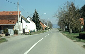
 Ulica u Sesvetama kod Pleternice
| |
Sesvete su naselje u Republici Hrvatskoj u Požeško-slavonskoj županiji, u sastavu grada Pleternice.
Zemljopis
Sesvete su smješte oko 6 km sjeverno od Pleternice, susjedna naselja su Gradac i Ašikovci na jugu, Ćosinac i Grabarje na sjeveru, te Lakušija na zapadu. Nalaze se u središnjem ravničarskom dijelu Požeške zlatne doline u tzv. Poljadiji. Nadmorska visina iznosi 171 metar. Vlada umjerena kontinentalna klima.
Povijesne zemljopisne karte na kojima je vidljivo naselje Sesvete:
- First Military Survey (1763-1787)[1]
- Second Military Survey (1806-1869)[2]
- Third Military Survey (1869-1887)[3]
- Hungarian Kingdom (1869-1887)[4]
- Cadastral maps (XIX. century)[5]
- Google Earth[6]
- Google karte[7]
Stanovništvo
Prema popisu stanovništva iz 2011. godine Sesvete su imale 128 stanovnika.
Kretanje broja stanovnika 1857.-2011.[8][9]
<timeline>
Colors=
id:lightgrey value:gray(0.9)
id:darkgrey  value:gray(0.7)
id:sfondo value:rgb(1,1,1)
id:barra value:rgb(0.6,0.7,0.8)
ImageSize = width:500 height:400 PlotArea = left:50 bottom:50 top:30 right:30 DateFormat = x.y Period = from:0 till:287 TimeAxis = orientation:vertical AlignBars = justify ScaleMajor = gridcolor:darkgrey increment:50 start:0 ScaleMinor = gridcolor:lightgrey increment:25 start:0 BackgroundColors = canvas:sfondo
BarData=
bar:1857 text:1857.
bar:1869 text:1869.
bar:1880 text:1880.
bar:1890 text:1890.
bar:1900 text:1900.
bar:1910 text:1910.
bar:1921 text:1921.
bar:1931 text:1931.
bar:1948 text:1948.
bar:1953 text:1953.
bar:1961 text:1961.
bar:1971 text:1971.
bar:1981 text:1981.
bar:1991 text:1991.
bar:2001 text:2001.
bar:2011 text:2011.
PlotData=
color:barra width:20 align:left
bar:1857 from:0 till: 145
bar:1869 from:0 till: 164
bar:1880 from:0 till: 184
bar:1890 from:0 till: 196
bar:1900 from:0 till: 241
bar:1910 from:0 till: 239
bar:1921 from:0 till: 258
bar:1931 from:0 till: 287
bar:1948 from:0 till: 282
bar:1953 from:0 till: 275
bar:1961 from:0 till: 238
bar:1971 from:0 till: 187
bar:1981 from:0 till: 156
bar:1991 from:0 till: 137
bar:2001 from:0 till: 130
bar:2011 from:0 till: 128
PlotData=
bar:1857 at: 145 fontsize:S text: 145 shift:(-10,5)
bar:1869 at: 164 fontsize:S text: 164 shift:(-10,5)
bar:1880 at: 184 fontsize:S text: 184 shift:(-10,5)
bar:1890 at: 196 fontsize:S text: 196 shift:(-10,5)
bar:1900 at: 241 fontsize:S text: 241 shift:(-10,5)
bar:1910 at: 239 fontsize:S text: 239 shift:(-10,5)
bar:1921 at: 258 fontsize:S text: 258 shift:(-10,5)
bar:1931 at: 287 fontsize:S text: 287 shift:(-10,5)
bar:1948 at: 282 fontsize:S text: 282 shift:(-10,5)
bar:1953 at: 275 fontsize:S text: 275 shift:(-10,5)
bar:1961 at: 238 fontsize:S text: 238 shift:(-10,5)
bar:1971 at: 187 fontsize:S text: 187 shift:(-10,5)
bar:1981 at: 156 fontsize:S text: 156 shift:(-10,5)
bar:1991 at: 137 fontsize:S text: 137 shift:(-10,5)
bar:2001 at: 130 fontsize:S text: 130 shift:(-10,5)
bar:2011 at: 128 fontsize:S text: 128 shift:(-10,5)
TextData=
fontsize:S pos:(20,20)
text:Izvor – Državni zavod za statistiku
</timeline>
Stanovništvo Sesveta prema starosti i spolu iz Popisa stanovništva Republike Hrvatske 2011. godine:[10]
| Spol | Ukupno | Starost | ||||||||||||||||
|---|---|---|---|---|---|---|---|---|---|---|---|---|---|---|---|---|---|---|
| 0-4 | 5-9 | 10-14 | 15-19 | 20-24 | 25-29 | 30-34 | 35-39 | 40-44 | 45-49 | 50-54 | 55-59 | 60-64 | 65-69 | 70-74 | 75-79 | 80-84 | ||
| 128 | 7 | 7 | 7 | 11 | 8 | 9 | 10 | 6 | 14 | 7 | 9 | 5 | 6 | 3 | 5 | 10 | 4 | |
| m | 72 | 6 | 5 | 3 | 9 | 4 | 5 | 5 | 3 | 7 | 5 | 4 | 4 | 2 | 1 | 2 | 5 | 2 |
| ž | 56 | 1 | 2 | 4 | 2 | 4 | 4 | 5 | 3 | 7 | 2 | 5 | 1 | 4 | 2 | 3 | 5 | 2 |
Napomena: Sesvete se od 1910. do 1981. iskazivaju pod imenom Sesvete Požeške.
Obrazovanje
Pučku školu u Sesvetama 1759. godine osnovali su požeški isusovci zajedno sa školom u Kutjevu. Danas djeluje kao područna škola u sastavu Osnovne škole fra Kaje Adžića Pleternica.
Društava koja djeluju u Sesvetama
- Župa Svih Svetih Sesvete
- Dobrovoljno vatrogasno društvo Požeške Sesvete
- Lovačko društvo Vražjak
- Učenička zadruga Neven
- Hrvatsko žensko društvo - ogranak Sesvete
- Biciklistička udruga Tim guvernal
Poznate osobe
- Ivan Švear - povjesničar
- Branko Živković - književnik, specijalist ginekologije
- Marko Baričević - saborski zastupnik
Izvor
- ↑ First Military Survey (1763-1787). http://mapire.eu/en/map/firstsurvey/?layers=osm%2C1%2C73&bbox=1982721.0012218743%2C5674201.542942032%2C1989246.8125117212%2C5676881.616246281 0.
- ↑ Second Military Survey (1806-1869). http://mapire.eu/en/map/secondsurvey/?layers=osm%2C5%2C42&bbox=1982647.5262322407%2C5674001.823951186%2C1989173.3375220876%2C5676681.897255435 0.
- ↑ Third Military Survey (1869-1887). http://mapire.eu/en/map/hkf_75e/?layers=osm%2C8&bbox=1982418.2151473854%2C5673970.771408445%2C1988944.0264372323%2C5676650.844712694 0.
- ↑ Hungarian Kingdom (1869-1887). http://mapire.eu/en/map/hkf_25e/?layers=osm%2C11&bbox=1983598.2117715375%2C5674737.53034843%2C1986861.117416461%2C5676077.567000556 0.
- ↑ Cadastral maps (XIX. century). http://mapire.eu/en/map/cadastral/?layers=osm%2C43%2C44&bbox=1972046.6658719406%2C5671235.758990116%2C1998149.9110313281%2C5681956.052207112 0.
- ↑ Google Earth.
- ↑ Google karte. https://www.google.hr/maps/search/sesvete+po%C5%BEe%C5%A1ke/@45.3390929,17.824275,2243m/data=!3m1!1e3 0.
- ↑ Naselja i stanovništvo Republike Hrvatske 1857.-2001., www.dzs.hr
- ↑ Popis stanovništva Republike Hrvatske 2011., www.dzs.hr
- ↑ Popis stanovništva Republike Hrvatske 2011.
Datoteka:Noia 64 filesystems home white.png![]() Nedovršeni članak Sesvete (Pleternica) koji govori o naselju u Hrvatskoj treba dopuniti. Dopunite ga prema pravilima uređivanja Hrvatske internetske enciklopedije.
Nedovršeni članak Sesvete (Pleternica) koji govori o naselju u Hrvatskoj treba dopuniti. Dopunite ga prema pravilima uređivanja Hrvatske internetske enciklopedije.
| |||||||