Datoteka:Verbreitungsgebiet der Tataren.PNG
Izvor: Hrvatska internetska enciklopedija
Veličina ovog prikaza: 800 × 285 piksela. Ostale razlučivosti: 320 × 114 piksela | 1.077 × 384 piksela.
Vidi sliku u punoj veličini ((1.077 × 384 piksela, veličina datoteke: 13 KB, <a href="/wiki/MIME" title="MIME">MIME</a> tip: image/png))
| Ova je datoteka sa stranica Zajedničkog poslužitelja Zaklade Wikimedije i smiju je rabiti drugi projekti. Opis s njezine stranice s opisom datoteke prikazan je ispod. |

|
This ethnographic map image could be re-created using vector graphics as an SVG file. This has several advantages; see Commons:Media for cleanup for more information. If an SVG form of this image is available, please upload it and afterwards replace this template with
{{vector version available|new image name}}.
It is recommended to name the SVG file “Verbreitungsgebiet der Tataren.svg”—then the template Vector version available (or Vva) does not need the new image name parameter. |
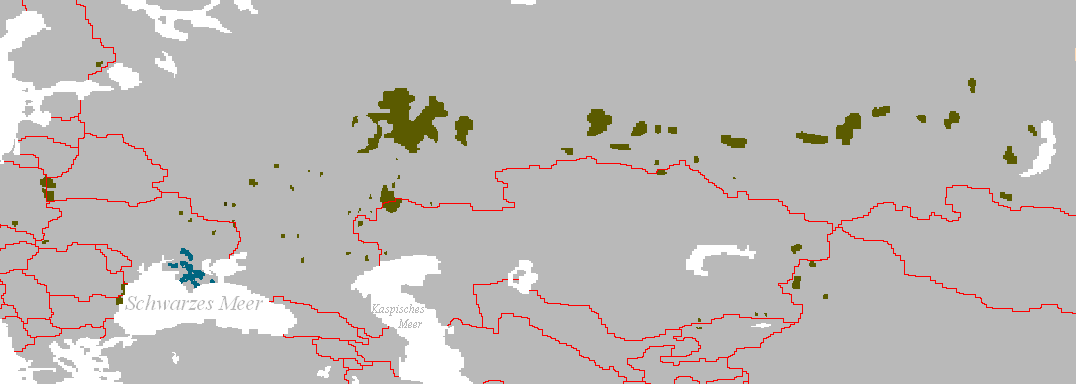
Verbreitungsgebiet der Turko-Tataren
- Beschreibung: Darstellungskarte mit den Siedlungsgebieten jener Völker, die sich heute als „Tataren“ bezeichnen bzw. sich von diesen herführen.
- Zeichner: Postmann Michael
- erstellt am: 13. Februar 2005
| |
Ovo djelo je u javno vlasništvo izdao autor: Postmann Michael, at the engleski Wikipedija project. To vrijedi za cijeli svijet. In case this is not legally possible: |
Povijest datoteke
Kliknite na datum/vrijeme kako biste vidjeli datoteku kakva je tada bila.
| Datum/Vrijeme | Minijatura | Dimenzije | Suradnik | Komentar | |
|---|---|---|---|---|---|
| sadašnja | 15:56, 3. lipnja 2024. | 1.077 × 384 (13 KB) | Sakaiberian | Reverted to version as of 08:36, 10 July 2017 (UTC) |
Poveznice
Na ovu sliku vode poveznice sa sljedećih stranica: