Veličina ovog PNG prikaza ove SVG datoteke: 680 × 520 piksela. Ostale razlučivosti: 314 × 240 piksela | 628 × 480 piksela | 785 × 600 piksela | 1.004 × 768 piksela | 1.280 × 979 piksela | 2.560 × 1.958 piksela.
Vidi sliku u punoj veličini (SVG datoteka, nominalno 680 × 520 piksela, veličina datoteke: 662 KB)
| Ova je datoteka sa stranica Zajedničkog poslužitelja Zaklade Wikimedije i smiju je rabiti drugi projekti. Opis s njezine stranice s opisom datoteke prikazan je ispod. |
| Datasource (reference to visualized facts) is not provided for the data that is visualized in this self-made work. |
The factual accuracy of this map or the file name is disputed.
Reason: The de-facto state of Kosovo does not have a slavic national language. |  |
Sažetak
| OpisSlavic europe.svg |
العربية:
Беларуская:
Български:
Čeština:
Deutsch:
English:
Esperanto:
Español:
Français :
עברית:
ქართული:
Македонски:
Nederlands:
Polski:
Português:
Română:
Русский:
Slovenčina:
Српски / srpski:
Українська: |
| Datum | |
| Izvor | self-made - based upon: Image:Slavic europe.png |
| Autor | CrazyPhunk |
| Ostale inačice |
Radovi izvedeni od ove datoteke: |
Licencija

|
Dozvoljava se umnožavanje, dijeljenje i/ili mijenjanje ovog dokumenta pod uvjetima GNU-ove licence za slobodnu dokumentaciju, inačica 1.2 ili kasnija ako ju je objavio Free Software Foundation; bez nepromjenjivih ili obveznih dijelova i bez teksta na naslovnoj i/ili posljednjoj stranici. Kopija licencije je uključena u odjeljak naslovljen GNU-ove licence za slobodnu dokumentaciju.http://www.gnu.org/copyleft/fdl.htmlGFDLGNU Free Documentation Licensetruetrue |
| Ova datoteka je licencirana pod Creative Commons Imenovanje-Dijeli pod istim uvjetima 3.0 nelokaliziranom licencijom. | ||
| ||
| Ova oznaka za licenciranje dodana je datoteci kao dio GFDL ažuriranja licnciranja.http://creativecommons.org/licenses/by-sa/3.0/CC BY-SA 3.0Creative Commons Attribution-Share Alike 3.0truetrue |
Opisi
Dodajte kratko objašnjenje što predstavlja ova datoteka
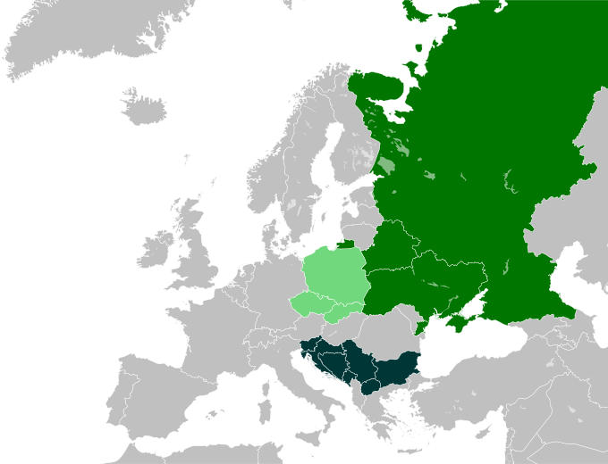
Staaten, in denen eine slawische Sprache die Nationalsprache ist
Країни, де державні мови - слов'янські
Státy, ve kterých je slovanský jazyk národním jazykem
Štáty, v ktorých je slovanský jazyk národným jazykom
Predmeti prikazani u ovoj datoteci
motiv
Određene vrijednosti bez stavke na projektu Wikipodatci
16. svibnja 2007
image/svg+xml
Povijest datoteke
Kliknite na datum/vrijeme kako biste vidjeli datoteku kakva je tada bila.
| Datum/Vrijeme | Minijatura | Dimenzije | Suradnik | Komentar | |
|---|---|---|---|---|---|
| sadašnja | 20:24, 9. veljače 2024. |  | 680 × 520 (662 KB) | Ruach Chayim | Reverted to version as of 00:00, 23 January 2024 (UTC) |
Poveznice
Na ovu sliku vode poveznice sa sljedećih stranica:
Metapodatci
Ova datoteka sadržava dodatne podatke koje je vjerojatno dodala digitalna kamera ili skener u procesu snimanja odnosno digitalizacije. Ako je datoteka mijenjana, podatci možda nisu u skladu sa stvarnim stanjem.
| Kratki naslov | Countries of Europe |
|---|---|
| Ime slike | A blank Map of Europe. Every country has an id which is its ISO-3166-1-ALPHA2 code in lower case.
Members of the EU have a class="eu", countries in europe (which I found turkey to be but russia not) have a class="europe".
Certain countries are further subdivided the United Kingdom has gb-gbn for Great Britain and gb-nir for Northern Ireland. Russia is divided into ru-kgd for the Kaliningrad Oblast and ru-main for the Main body of Russia. There is the additional grouping #xb for the "British Islands" (the UK with its Crown Dependencies - Jersey, Guernsey and the Isle of Man) and the Kingdom of Denmark (Denmark, Faroe Islands, Greenland)

Contributors.
Original Image: (http://commons.wikimedia.org/wiki/Image:Europe_countries.svg) Júlio Reis (http://commons.wikimedia.org/wiki/User:Tintazul).
Recolouring and tagging with country codes: Marian "maix" Sigler (http://commons.wikimedia.org/wiki/User:Maix)
Improved geographical features: http://commons.wikimedia.org/wiki/User:W!B:
Updated to reflect dissolution of Serbia & Montenegro: http://commons.wikimedia.org/wiki/User:Zirland
Updated to include British Crown Dependencies as seperate entities and regroup them as "British Islands", with some simplifications to the XML and CSS: James Hardy (http://commons.wikimedia.org/wiki/User:MrWeeble)
Validated (http://commons.wikimedia.org/wiki/User:CarolSpears)
Changed the country code of Serbia to RS per http://en.wikipedia.org/wiki/Serbian_country_codes and the file http://www.iso.org/iso/iso3166_en_code_lists.txt (http://commons.wikimedia.org/wiki/User:TimothyBourke)
Uploaded on behalf of User:Checkit, direct complaints to him plox: 'Moved countries out of the "outlines" group, removed "outlines" style class, remove separate style information for Russia' (http://commons.wikimedia.org/wiki/User:Collard)
Updated various coastlines and boarders and added various islands not previously shown (details follow). Added Kosovo, Northern Cyprus, Crimea, Abkhazia, South Ossetia, Transnistria and Nagorno-Karabakh as disputed territories. Moved major lakes to their own object and added more. List of updated boarders/coastlines: British Isles (+ added Isle of Wight, Skye, various smaller islands), the Netherlands, Germany, Austria, Hungary, Czech Republic, Denmark, Sweden, Finland, Poland, Kaliningrad Oblast of the Russian Federation (and minor tweaks to Lithuania), Estonia, Ukraine, Moldova (minor), Romania, Bulgaria, Turkey, Greece, F.Y.R. Macedonia, Serbia, Bosnia and Herzegovina, Montenegro, Albania, Croatia, Italy (mainland and Sicily), Malta (http://commons.wikimedia.org/wiki/User:Alphathon).
Added Bornholm (http://commons.wikimedia.org/wiki/User:Heb)
Released under CreativeCommons Attribution ShareAlike (http://creativecommons.org/licenses/by-sa/2.5/). |
| Širina | 680 |
| Visina | 520 |
Dobavljeno iz "https://enciklopedija.cc/wiki/Datoteka:Slavic_europe.svg"