Datoteka:Rs-Sachalin-map.png
Izvor: Hrvatska internetska enciklopedija
Viša rezolucija nije dostupna.
Rs-Sachalin-map.png ((636 × 326 piksela, veličina datoteke: 106 KB, <a href="/wiki/MIME" title="MIME">MIME</a> tip: image/png))
| Ova je datoteka sa stranica Zajedničkog poslužitelja Zaklade Wikimedije i smiju je rabiti drugi projekti. Opis s njezine stranice s opisom datoteke prikazan je ispod. |
Sažetak
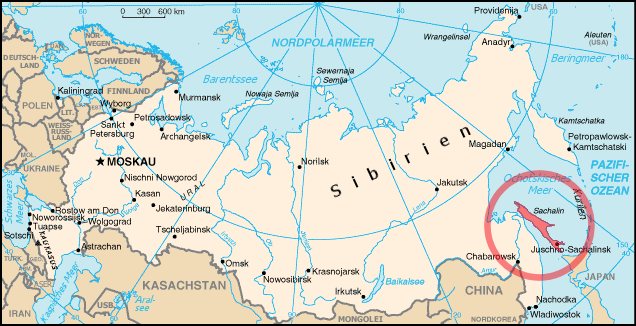
| Opis | Position of Sachalin island |
| Datum | |
| Izvor | Edited Rs-map.png from German Wikipedia |
| Autor | ErnstA |
| Dopuštenje (Naknadna uporaba ove datoteke) |
Public Domain |
Licencija
This work is in the public domain in the United States because it is a work prepared by an officer or employee of the United States Government as part of that person’s official duties under the terms of Title 17, Chapter 1, Section 105 of the US Code.
Note: This only applies to original works of the Federal Government and not to the work of any individual U.S. state, territory, commonwealth, county, municipality, or any other subdivision. This template also does not apply to postage stamp designs published by the United States Postal Service since 1978. (See § 313.6(C)(1) of Compendium of U.S. Copyright Office Practices). It also does not apply to certain US coins; see The US Mint Terms of Use.
|
 | |
| Ova datoteka je identificirana kao slobodna od poznatih ograničenja po zakonu o autorskim pravima, uključujući sva povezana i srodna prava. | ||
Povijest datoteke
Kliknite na datum/vrijeme kako biste vidjeli datoteku kakva je tada bila.
| Datum/Vrijeme | Minijatura | Dimenzije | Suradnik | Komentar | |
|---|---|---|---|---|---|
| sadašnja | 17:30, 16. kolovoza 2006. | | 636 × 326 (106 KB) | ErnstA~commonswiki | {{Information |Description= Position of Sachalin island |Source= Edited Rs-map.png from German Wikipedia |Date= 16 AUG 2006 |Author= ErnstA |Permission= Public Domain |other_versions= none }} |
Poveznice
Na ovu sliku vode poveznice sa sljedećih stranica: