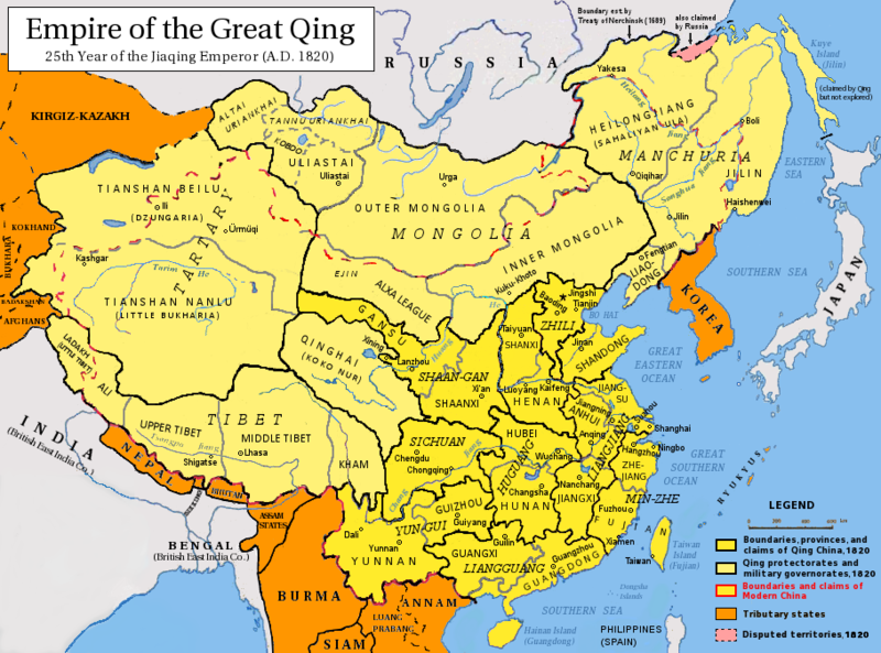
Datoteka:Qing Dynasty 1820.png

Vidi sliku u punoj veličini ((910 × 675 piksela, veličina datoteke: 398 KB, <a href="/wiki/MIME" title="MIME">MIME</a> tip: image/png))
| Ova je datoteka sa stranica Zajedničkog poslužitelja Zaklade Wikimedije i smiju je rabiti drugi projekti. Opis s njezine stranice s opisom datoteke prikazan je ispod. |
| The image contains one or several undisputed inaccuracies.
It should not be used to illustrate or provide information about the subject, but may be kept in order to provide the basis for a corrected image. If you disagree that it may be useful for this purpose feel free to request deletion. Reason:
1) Did Haishenwei/Haishenwai exist in 1820? 2) Compare Tibet's northern boundary to https://commons.wikimedia.org/wiki/File:Qing_dynasty_and_Tibet.jpg which is a much different boundary from the same year.
See the talk page for further information. |
References for this description (or part of this) or for the depiction in the file are not provided.
|

|
This historical map image could be re-created using vector graphics as an SVG file. This has several advantages; see Commons:Media for cleanup for more information. If an SVG form of this image is available, please upload it and afterwards replace this template with
{{vector version available|new image name}}.
It is recommended to name the SVG file “Qing Dynasty 1820.svg”—then the template Vector version available (or Vva) does not need the new image name parameter. |
This image is very small, unfixably too light/dark, or may not adequately illustrate the subject of the image. If a higher-quality version of this particular image is available, please replace this one; otherwise, a supplemental image illustrating this subject and available under a free license should be found or provided and uploaded as a separate file.
Please see Category:Image cleanup templates for templates used to mark images that only need a clean-up. For more help, see Commons:Media for cleanup#Low quality images. العربية ∙ беларуская (тарашкевіца) ∙ català ∙ čeština ∙ Deutsch ∙ English ∙ español ∙ فارسی ∙ suomi ∙ français ∙ galego ∙ magyar ∙ italiano ∙ 日本語 ∙ ಕನ್ನಡ ∙ 한국어 ∙ македонски ∙ മലയാളം ∙ Plattdüütsch ∙ Nederlands ∙ norsk ∙ polski ∙ português ∙ русский ∙ sicilianu ∙ slovenščina ∙ svenska ∙ Tiếng Việt ∙ 中文 ∙ 中文(简体) ∙ 中文(繁體) ∙ 中文(臺灣) ∙ +/− |
Sažetak
| OpisQing Dynasty 1820.png |
English: Map of the Qing Dynasty in 1820, representing its stablized territory from 1790-1839. (Includes provincial boundaries and the boundaries of modern China for reference.) Provinces in yellow, military governorates and protectorates in light yellow, tributary states in orange.
Adapted from File:ROC_PRC_comparison_eng.jpg and information complied from:
中文(简体):大清嘉庆二十五年疆域图。约合1790-1839稳定时期疆域。
中文(繁體):大清嘉慶廿五年疆域圖。約合1790-1839穩定時期疆域。
日本語: 大清の嘉慶25年の疆域の図。
Tiếng Việt: Đại Thanh bản đồ (1820).
Français : Carte du Grand Empire des Qing la 25e année Jiaqing du règne de l'empereur Qing Jiaqing (1820). Cette carte inclus les frontières provinciales et les frontières de la chine contemporaine pour référence. Les provinces sont en jaune, les gouvernorats et protectorats militaires en jaune claire, les états tributaires en orange. |
| Datum | |
| Izvor | Vlastito djelo postavljača |
| Autor | Pryaltonian |
| Ostale inačice | File:Qing_1820_CHGIS.png |
Licencija
- Slobodno smijete:
- dijeliti – umnožavati, distribuirati i javnosti priopćavati djelo
- remiksirati – prerađivati djelo
- Pod sljedećim uvjetima:
- imenovanje autora – Morate pripisati odgovarajuće autorske zasluge, dati poveznicu na licenciju, te naznačiti jesu li načinjene promjene autorskog djela. Prethodno navedeno možete učiniti na svaki razuman način, ali ne na način koji bi sugerirao da Vi ili Vaše korištenje licencorova djela ima izravno licencorovo odobrenje.
- dijeli pod istim uvjetima – Ako ovo djelo izmijenite, preoblikujete ili stvarate na osnovu tog materijala, svoje doprinose morate distribuirati pod istom ili kompatibilnom licencijom kao što je i licencija originala.

|
Dozvoljava se umnožavanje, dijeljenje i/ili mijenjanje ovog dokumenta pod uvjetima GNU-ove licence za slobodnu dokumentaciju, inačica 1.2 ili kasnija ako ju je objavio Free Software Foundation; bez nepromjenjivih ili obveznih dijelova i bez teksta na naslovnoj i/ili posljednjoj stranici. Kopija licencije je uključena u odjeljak naslovljen GNU-ove licence za slobodnu dokumentaciju.http://www.gnu.org/copyleft/fdl.htmlGFDLGNU Free Documentation Licensetruetrue |
See also
-
1820 Map of Asia by Daniel Lizars
-
1851 map of Tibet, Mongolia and Manchuria by John Tallis
-
1844 map of China and Japan by John Nicaragua Dower
-
1833 French map of China and Japan
-
1832 French map of China and Japan
-
1836 French map of China and Japan
Opisi
Predmeti prikazani u ovoj datoteci
motiv
Određene vrijednosti bez stavke na projektu Wikipodatci
27. rujna 2008
Povijest datoteke
Kliknite na datum/vrijeme kako biste vidjeli datoteku kakva je tada bila.
| Datum/Vrijeme | Minijatura | Dimenzije | Suradnik | Komentar | |
|---|---|---|---|---|---|
| sadašnja | 05:15, 17. svibnja 2014. |  | 910 × 675 (398 KB) | Tenohira | fix |
Poveznice
Na ovu sliku vode poveznice sa sljedećih stranica:
Metapodatci
Ova datoteka sadržava dodatne podatke koje je vjerojatno dodala digitalna kamera ili skener u procesu snimanja odnosno digitalizacije. Ako je datoteka mijenjana, podatci možda nisu u skladu sa stvarnim stanjem.
| Vodoravna razlučivost | 28,35 dpc |
|---|---|
| Okomita razlučivost | 28,35 dpc |
| Datum posljednje promjene datoteke | 05:12, 17. svibnja 2014. |


