

Veličina ovog prikaza: 470 × 599 piksela. Ostale razlučivosti: 188 × 240 piksela | 377 × 480 piksela | 1.020 × 1.300 piksela.
Vidi sliku u punoj veličini ((1.020 × 1.300 piksela, veličina datoteke: 535 KB, <a href="/wiki/MIME" title="MIME">MIME</a> tip: image/jpeg))
| Ova je datoteka sa stranica Zajedničkog poslužitelja Zaklade Wikimedije i smiju je rabiti drugi projekti. Opis s njezine stranice s opisom datoteke prikazan je ispod. |
This image is in the public domain in the United States because it only contains materials that originally came from the United States Geological Survey, an agency of the United States Department of the Interior. For more information, see the official USGS copyright policy.
|
| Descripcion |
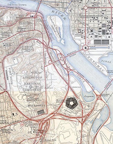
USGS topos covering the area around the Pentagon in Virginia, soon after the road network was built. Note that the Shirley Highway near the south edge of the map was added later, as it opened in 1943. |
|||||||||
| Izvor |
|
|||||||||
| Geotemporal data | ||||||||||
| Bounding box |
|
|||||||||
| Georeferencing | ||||||||||
Povijest datoteke
Kliknite na datum/vrijeme kako biste vidjeli datoteku kakva je tada bila.
| Datum/Vrijeme | Minijatura | Dimenzije | Suradnik | Komentar | |
|---|---|---|---|---|---|
| sadašnja | 19:31, 21. siječanj 2006. | | 1.020 × 1.300 (535 KB) | wikimediacommons>SPUI~commonswiki | {{PD-USGov-USGS}} USGS topos covering the area around the Pentagon in Virginia, soon after the road network was built. Note that the Shirley Highway near the southwest edge of the map was added later, as it opened in 1943. *North half: [http://historical. |
Poveznice
Na ovu sliku vode poveznice sa sljedećih stranica: