

Veličina ovog prikaza: 800 × 533 piksela. Ostale razlučivosti: 320 × 213 piksela | 640 × 427 piksela | 1.024 × 683 piksela | 1.280 × 853 piksela | 3.000 × 2.000 piksela.
Vidi sliku u punoj veličini ((3.000 × 2.000 piksela, veličina datoteke: 2,64 MB, <a href="/wiki/MIME" title="MIME">MIME</a> tip: image/jpeg))
| Ova je datoteka sa stranica Zajedničkog poslužitelja Zaklade Wikimedije i smiju je rabiti drugi projekti. Opis s njezine stranice s opisom datoteke prikazan je ispod. |
.jpg)
Sažetak
| Opis |
Deutsch: Grand Canyon, Sicht vom Yavapai Point
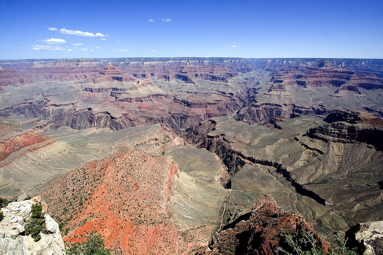
English: View from Yavapai Point. Brignt Angel Canyon, opposite Yavapai Point, (South Rim, view of Kaibab Plateau, North Rim). The thin, resistant en:Tapeats Sandstone forms the flatness in the inner canyon-(Tonto Platform), with the slope-forming units of Muav Limestone, and Bright Angel Shale accumulating upon it. The cliffs of the Redwall Limestone is one geologic layer above. (view slightly north-northwest) Isis Temple is the prominence in center. (Pipe Creek (canyon) is below on South Rim side). West of Isis Temple is Trinity Creek and its watershed canyon. Behind Isis Temple is the Phantom Creek, and watershed, with Buddha Temple and Buddha Cloister, just to the right (two points extend south to form Buddha Cloister -- Sturdevant Point, left, and Johnson Point (right over Bright Angel Canyon). (below, right, to Isis Temple) Cheops Pyramid (over whitish slopes). Isis Temple and Cheops Pyramid sit at the southwest fault block (a horst) at Bright Angel Canyon (and south wall of Phantom Creek (canyon)). The Grandview-Phantom faultline crosses, from NW to E-by-SE, (to Grandview Point-(South Rim), to turn, due-south). It intersects, here, at Granite Gorge with the Bright Angel Fault (NNE-by-SSW, approximate, north rim and south rim (up Indian Garden, Garden Creek)). The Unkar Group Horst which Isis and Cheops sit on has 3 sub-faults, as part of the horst-landform. The reddish and lavendar slopes at the promincence's base are Hakatai Shale, over Bsss Limestone. The Shinumo Quartzite forms the erosion-resistant cliff, above. (with no Tapeats Sandstone-(Tapeats Sea), the Shinumo was an island; instead, Bright Angel Shale, and Muav Limestone, above Note: Trinity Creek (watershed), left; Ninetyone Mile Creek wateshed (0.5 mi east); unnamed Wash, (drains Cheops Pyramid, on Unkar Group Horst), Wash = "Eightynine Mile Wash", and opposite outfall of Garden Creek (& Canyon, with en:Bright Angel Trail, from Maricopa Point region, South Rim); and Bright Angel Canyon (& Creek), photo right) |
| Datum | 04/06 |
| Izvor | Vlastito djelo postavljača |
| Autor | tom bernard anyz; Tenji at de.wikipedia |
Licencija
Tenji od de.wikipedia.org, nositelj autorskog prava za ovo djelo, ovime ga objavljuje pod sljedećom licencijom:

|
Dozvoljava se umnožavanje, dijeljenje i/ili mijenjanje ovog dokumenta pod uvjetima GNU-ove licence za slobodnu dokumentaciju, inačica 1.2 ili kasnija ako ju je objavio Free Software Foundation; bez nepromjenjivih ili obveznih dijelova i bez teksta na naslovnoj i/ili posljednjoj stranici. Kopija licencije je uključena u odjeljak naslovljen GNU-ove licence za slobodnu dokumentaciju. |
| Ova datoteka je licencirana pod Creative Commons Imenovanje-Dijeli pod istim uvjetima 3.0 nelokaliziranom licencijom. | ||
Autor:
| ||
| ||
| Ova oznaka za licenciranje dodana je datoteci kao dio GFDL ažuriranja licnciranja. |
Izvorna evidencija postavljanja
Prebačeno s de.wikipedia na Zajednički poslužitelj Prebacio suradnik Samoborac.
Izvorna stranica s opisom bila je ovdje. Niže navedena suradnička imena odnose se na de.wikipedia.
- 2006-07-25 06:29 Tenji 3000×2000×8 (2763423 bytes) * Bildbeschreibung: grand canyon * Quelle: selbst fotografiert * Fotograf/Zeichner: tom bernard anyz * Datum: 04/06
| Annotations | This image is annotated: View the annotations at Commons |
[[Category:Bass Formation
Povijest datoteke
Kliknite na datum/vrijeme kako biste vidjeli datoteku kakva je tada bila.
| Datum/Vrijeme | Minijatura | Dimenzije | Suradnik | Komentar | |
|---|---|---|---|---|---|
| sadašnja | 15:23, 10. ožujak 2008. | | 3.000 × 2.000 (2,64 MB) | wikimediacommons>File Upload Bot (Magnus Manske) | {{BotMoveToCommons|de.wikipedia}} {{Information |Description={{de|Grand canyon}} |Source=Transferred from [http://de.wikipedia.org de.wikipedia]; Transfer was stated to be made by User:Samoborac.<br/> (Original text : ''Selbst fotografiert'') |Date=0 |
Poveznice
Na ovu sliku vode poveznice sa sljedećih stranica:
.jpg)