Datoteka:Czechoslovakia.png
Izvor: Hrvatska internetska enciklopedija

Veličina ovog prikaza: 800 × 407 piksela. Ostale razlučivosti: 320 × 163 piksela | 640 × 325 piksela | 1.188 × 604 piksela.
Vidi sliku u punoj veličini ((1.188 × 604 piksela, veličina datoteke: 69 KB, <a href="/wiki/MIME" title="MIME">MIME</a> tip: image/png))
| Ova je datoteka sa stranica Zajedničkog poslužitelja Zaklade Wikimedije i smiju je rabiti drugi projekti. Opis s njezine stranice s opisom datoteke prikazan je ispod. |

|
This historical map image could be re-created using vector graphics as an SVG file. This has several advantages; see Commons:Media for cleanup for more information. If an SVG form of this image is available, please upload it and afterwards replace this template with
{{vector version available|new image name}}.
It is recommended to name the SVG file “Czechoslovakia.svg”—then the template Vector version available (or Vva) does not need the new image name parameter. |
Sažetak
| Opis |
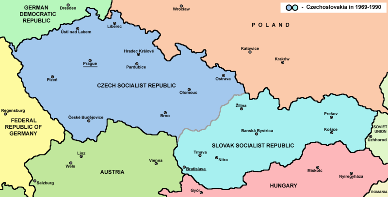
English: Map of Czechoslovakia in 1969-1990 |
| Izvor | Vlastito djelo postavljača |
| Autor | PANONIAN |
| Ostale inačice | Radovi izvedeni od ove datoteke: |


Licencija
| |
Ovo djelo je u javno vlasništvo izdao autor: PANONIAN, at the engleski Wikipedija project. To vrijedi za cijeli svijet. In case this is not legally possible: |
References
Main reference:
- Map is created according to this external source: http://www.tcnj.edu/~guhr2/images/czechoslovakia.jpg archive copy at the Wayback Machine
Secondary references with similar maps:
- http://1.bp.blogspot.com/_Qe1wgxDiEdU/TGti_qWpeYI/AAAAAAAABo0/sSqAfIpQMuU/s1600/1213M_CS.gif
- https://jspivey.wikispaces.com/file/view/T010895A.gif/34419939/T010895A.gif
- http://media.web.britannica.com/eb-media/84/105684-050-0D8412E3.gif archive copy at the Wayback Machine
- http://www.gatheringofisrael.com/atlas/europe/slavic/CS_prague.gif
- http://collections.lib.uwm.edu/agsmap/images/lg/DSCN1455.jpg[dead link]
- http://leccos.com/pics/pic/ceskoslovensko-_mapa_1950.jpg archive copy at the Wayback Machine
- http://www.math.sk/knor/GIF/mapa.gif
- http://ckpaji.sweb.cz/ceskoslovensko.jpg archive copy at the Wayback Machine
- http://www.power.szm.com/historia/mapa_TV_vysielacov_1978.jpg
Secondary references about Geo-political situation - published sources:
- The Times History of Europe, Times Books, London, 2002.
- Richard Overy, The Times History of the 20th Century, Times Books, London, 2004.
- The Times Atlas svjetske povijesti, Cankarjeva založba, Ljubljana - Zagreb, 1986.
- Istorijski atlas, Geokarta, Beograd, 1999.
- Školski istorijski atlas, Zavod za izdavanje udžbenika SR Srbije, Beograd, 1970.
- Povijesni atlas, Učila - Zagreb, Zagreb, 1971.
- Povijesni atlas za osnovnu školu, Kartografija - Tlos, Zagreb, 1975.
- Denis Šehić - Demir Šehić, Istorijski atlas sveta, Beograd, 2007.
Secondary reference about sizable cities:
|
|
This map image could be re-created using vector graphics as an SVG file. This has several advantages; see Commons:Media for cleanup for more information. If an SVG form of this image is available, please upload it and afterwards replace this template with
{{vector version available|new image name}}.
It is recommended to name the SVG file “Czechoslovakia.svg”—then the template Vector version available (or Vva) does not need the new image name parameter. |
The production, editing or release of this file was supported by the Community-Budget of Wikimedia Deutschland. To see other files made with the support of Wikimedia Deutschland, please see the category Supported by Wikimedia Deutschland. |
Povijest datoteke
Kliknite na datum/vrijeme kako biste vidjeli datoteku kakva je tada bila.
| Datum/Vrijeme | Minijatura | Dimenzije | Suradnik | Komentar | |
|---|---|---|---|---|---|
| sadašnja | 14:45, 12. srpnja 2022. | | 1.188 × 604 (69 KB) | Sebastian Wallroth | CROPPED |
Poveznice
Na ovu sliku vode poveznice sa sljedećih stranica: